Digital Tools to Facilitate Complete Trip Planning “Complete Trip” Concept Explained
- Date: January 6, 2023
Jump to section
The complete trip “synthesizes aspects of a person’s trip from the time the individual begins to plan the trip, to when he or she leaves the originating location when starting a journey, to the doorstep of the final destination,” as defined in the National Center for Mobility Management’s (NCMM) “The Complete Trip: Helping Customers Make a Seamless Journey.” The concept centers on the customer experience, treating each trip as a unique event that takes into account how the person interacts with various aspects of the trip. These interactions have physical aspects, such as the presence of a bus stop or a bike route in a person’s surroundings, but the interactions are psychological as well. Even if a trip appears successful on the surface, perhaps the person arrived at the destination more or less when they expected to, it is still possible for them to experience negative emotions throughout the trip experience. For example, an individual may feel stress and anxiety regarding certain trip components—they may wonder will I get there on time, what alternatives do I have if things don’t go as planned, am I safe, and a litany of other questions. Further, when people have strong doubts regarding the safety and comfort level of a trip, they may avoid it altogether.
What this boils down to is the real or perceived threat of uncertainty throughout the trip. By leveraging the complete trip concept, professionals have a tool to help illustrate the experience that people go through—if not the unique experience of each person, then a general approximation of what people with similar characteristics and concerns encounter. The benefit of having this structure is that professionals can identify known or likely challenges individuals come into contact with, and with this knowledge, they can go about identifying tactics to address these challenges. Ultimately, addressing such challenges reduces the uncertainty of a trip; the less uncertain a trip becomes, the less psychological strain is placed on a person. When they set out from home, the individual will have more confidence and trust in the transit and mobility system. This could very well contribute to the individual taking more trips and, as collective awareness of the improvements expands more broadly, the encouragement of others to consider trying transit for the first time.
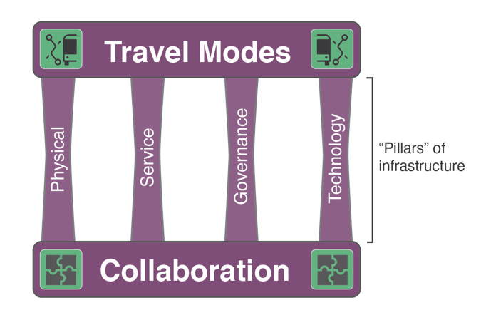
Components of the complete trip to take into account include:
Travel modes: Travel modes span options including walking, cycling, fixed-route transit, on-demand transit, demand-response transit, Americans with Disabilities Act (ADA) paratransit/human services transportation (HST), micromobility such as shared bikes and e-scooters, and others. These options can be used separately for single-mode trips or used together during intermodal trips.
Collaboration: Collaboration deals with how the actors involved in a complete trip-related effort work with each other. Formal collaboration could involve written agreements such as memorandums of understanding (MOU), but more often, collaboration happens informally.
Service infrastructure: This involves important aspects of service such as bus routes and schedules as well as transit agency websites that communicate policies and service details. Included within service infrastructure are elements that support customer service such as all the touch points that occur directly between the customer and the transit agency staff when customers speak with the bus operator or call a customer service line.
Governance infrastructure: Generally, governance can be thought of at three levels. The first level is at the level of a single transit agency, governing the relationship between the customer and the transit agency, which encompasses agency policies such as payment structures and passenger codes of conduct. The second level is the multi-transit agency level, governing the relationship between the customer and multiple transit agencies together, involving policies such as transfer agreements and reciprocity of ADA paratransit eligibility. The third level is the mobility system level, governing the relationship between the customer and the mobility system, which deals with policies such as monthly mobility subscription models for payment that offer a bulk discount of sorts in exchange for committing to several modes at one time and for a certain duration.
Physical infrastructure: This encompasses all the fixed and rolling assets within the transit and mobility system such as sidewalks, bus stops, and buses.
Technology infrastructure: There are generally two types of technology infrastructure. The first is directed toward the customer and assists with planning, booking, paying, and completing other customer tasks online, on mobile devices, and over the phone. The second supports the transit system and the work of its staff more generally such as on-demand route generation, computer-aided dispatch, and automatic vehicle location. While the focus of this guidebook is on the former, trip planning in particular, it should be noted that in some cases these types of technology infrastructure and data can intersect and benefit each other. For example, real time bus location data became available to customers in part because transit agencies initially generated the data for their own operational purposes. Automatic vehicle location (AVL) data were commonly set up so that agencies could see where all the vehicles were in real time and the operation headquarters, for example, could know immediately when a bus was running behind schedule without any direct communication with the bus operator. In time, it became clear these data would also be useful for the customer, and currently this is a common type of data to make available to the customer—often available as real time vehicle alerts in apps. This can also work in the other direction, such as when the public reports on the crowding status of vehicles, either actively or passively through their phone’s location, to give warning to other passengers on real time crowding conditions. By tracking public reports on vehicle crowding over time, a transit agency may gain insight into vehicle planning needs such as adding more cars onto a train or increasing the frequency of a busy bus route in order to reduce overall passenger crowding.
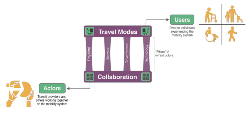
Actors typically involved in supporting these components include:
- Any organization directly responsible for planning and/or implementing physical, service, governance, and technology infrastructure for any of the travel modes in a mobility system.
- In addition to organizations that are directly responsible, others may be involved including regional organizations such as regional commissions and councils of governments, economic development organizations, and state-level organizations such as departments of transportation and human service organizations.
The “transit and mobility system” can differ widely from place to place and may be more of a conceptual grouping of the travel options available than a formal consortium of mobility providers that have agreed to combine their efforts. In highly rural areas, for example, it is common to have demand-response transit available as the only travel mode, outside of walking, cycling, and driving, in certain areas. In highly urban areas, it is common to have all of the travel modes listed above present. Although the overall goal for either area may be to fill in mobility gaps and make improvements, the challenges are very different. A common challenge for the former often involves improving and expanding the few options that are available, while the challenge for the latter often centers on better integrating all the available options—typically across the public and private sectors.
Depending on how the transit and mobility system is formally defined, actors will be involved in various roles. In highly urban areas with multiple transit agencies and many travel modes, for example, regional organizations are often heavily involved in coordinating activities across mobility providers and with those directly responsible for physical infrastructure. State-level organizations may also be involved in decision-making, particularly for federal and state funding decisions. Each geographic area is unique in terms of how all the actors in the area work together.
The federal government has become involved in contributing to innovation for the complete trip concept. In early 2020, the U.S. Department of Transportation (USDOT) announced a funding effort called the “Complete Trip – ITS4US Deployment Program.” More than $38 million was awarded to five grantees across three phases of activity with the purpose to “identify ways to provide more efficient, affordable, and accessible transportation options for underserved communities that often face greater challenges in accessing essential services. The program aims to solve mobility challenges for all travelers with a specific focus on underserved communities, including people with disabilities, older adults, low-income individuals, rural residents, veterans, and limited English proficiency travelers.” The five grantees are currently working on the first phase of their projects, which is focused on concept development. More details about the current projects and future plans are available on the Complete Trip – ITS4US Deployment Program website.
The complete trip concept relates to, and in some ways has overlap with, two other concepts including Mobility as a Service (MaaS) and One-Call/One-Click (OC/OC) systems. MaaS is “an integrated mobility concept in which travelers can access their transportation modes over a single digital interface. MaaS primarily focuses on passenger mobility allowing travelers to seamlessly plan, book, and pay for travel on a pay- as-you-go and/or subscription basis.” One way of comparing the complete trip concept to MaaS is to point out that while they both involve including all of the travel modes in a geographic area, MaaS is much more focused on the “technology infrastructure” component—digital technology that is online and on mobile devices in particular—while leveraging physical, service, and governance infrastructure to its ends.
OC/OC systems “inform the public about most, if not all, available transportation options for all populations in a given geographic area” and “enable users to access trip information; where required, confirm eligibility for and book trips; and pay for trips. This allows community members to plan and implement travel within a single system or seamlessly across multiple systems.” The same type of comparison between the complete trip and MaaS also applies to OC/OC systems (i.e., a focus on the “technology infrastructure” component), with the main difference that the technology for OC/OC systems does not necessarily depend on digital technology; call-based technology is an explicit part of the concept.
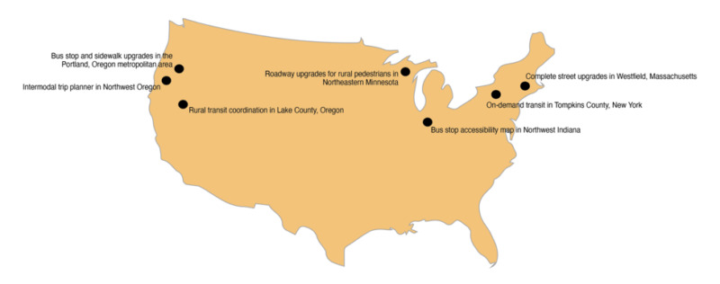
The Guidebook includes seven “highlighted projects” in chapter 1 and chapter 2; each project is a window into specific types of improvements for the complete trip. The map below shows the locations of these US-based projects. In chapter 1, the projects deal more with physical infrastructure improvements, while the projects in chapter 2 involve improvements in technology infrastructure—both types contributing to progress for the complete trip.
Milestones and Segments of the Complete Trip
Travel modes such as walking, cycling, fixed-route transit, on-demand transit, demand-response transit, Americans with Disabilities Act (ADA) paratransit/human-services transportation (HST), and micromobility (e.g., shared bikes and e-scooters), used separately for single-mode trips or used together during intermodal trips, each have their own distinct trip process. The “journey diagram” graphics (below) provide a generalized illustration of typical end-to-end journeys, but do not address the full range of all journey possibilities. Most end-to-end journeys have similar “milestones” including:
- Evaluate options
- Select option (with booking and payment as required)
- Depart from origin
- Enter/begin use of vehicle
- Exit/end use of vehicle
- Arrive at destination
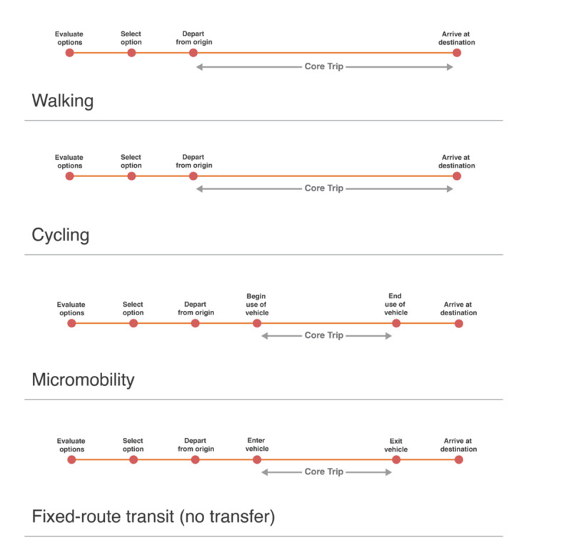
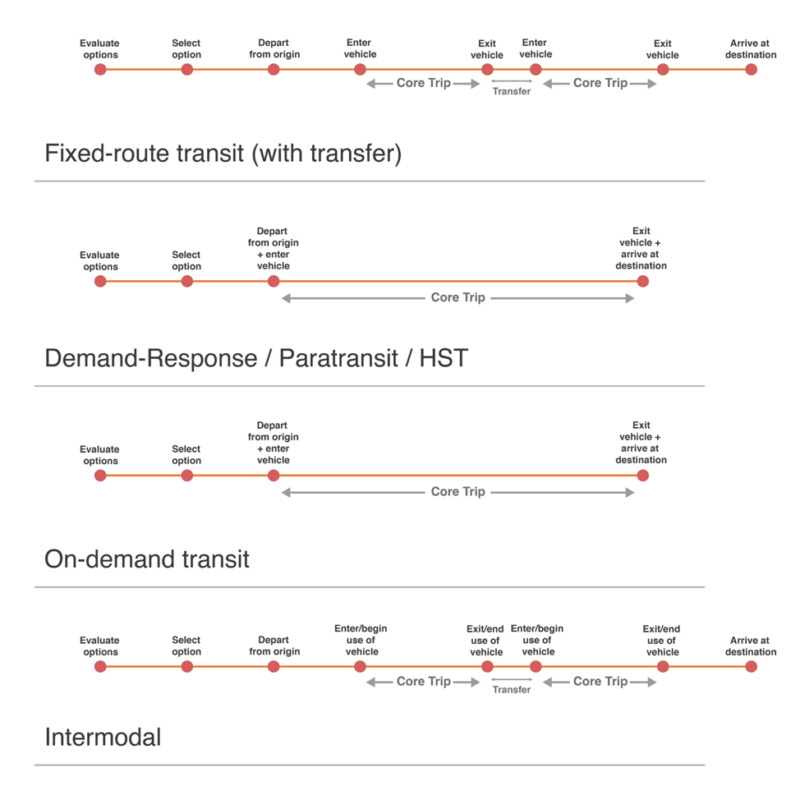
A journey “segment” refers to the customer experience between two milestones. For modes involving a vehicle, the segment that exists between the enter/begin use of vehicle and exit/end use of vehicle milestones is the “core trip”—the period of the journey that involves the customer riding in/on the vehicle. When an intermodal trip takes place, there are actually two core trips, one for each mode, and the segment between ending one core trip and beginning the other is the transfer. By adding more variables, intermodal end-to-end journeys become more complex. Payment reconciliation among various actors may also occur after the journey is complete, for some intermodal or multi-jurisdictional trips.
The main innovation of the complete trip concept is that it calls upon professionals to give just as much attention to all the other journey segments as is often given to the core trip. By considering each end-to-end journey type, with all its milestones and segments, how each journey works in reality becomes more transparently displayed—its gaps and shortcomings for the customer experience are less likely to remain hidden.
Factors Influencing Journey Feasibility for Individuals
Understanding the challenges that people face during their end-to-end journeys involves considering each segment separately and how the segments connect to each other to comprise the end-to-end journey. A potential tactic to address challenges may apply to a single segment (i.e., improved sidewalks encountered between “depart from origin” and “enter/begin use of vehicle”), or even multiple segments, but will rarely be able to address challenges for the entire end-to-end journey. Therefore, when developing ideas to improve the complete trip, it is important to consider many tactics that address specific journey segments. Ultimately, it is how all of these tactics are applied in unison that determines how successful an overall complete trip effort will be in reducing challenges for individuals.
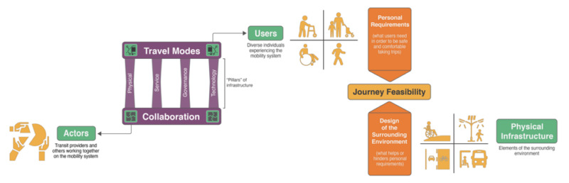
Journey diagrams are helpful because they illustrate the customer experience in a simplified format, giving a bird’s eye view of the situation. They can also help with another key step in understanding the complete trip—clarifying the range of individual experiences across modes. How an individual experiences an end-to-end journey primarily deals with two factors, their personal requirements and the design of the surrounding environment as shown below.
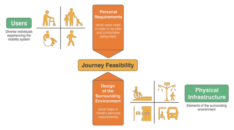
Personal Requirements
Personal requirements influence the ability of an individual to access certain end-to-end journeys; they can even determine if a mode is feasible at all. While some personal requirements are related to an individual’s disability, other requirements are related to how an individual perceives their travel experience more generally; both may involve a complex mental calculation to assess the levels of uncertainty for factors such as safety and comfort.
One category of personal requirements pertains to disabilities, such as cognitive, hearing, mobility, and visual impairments, as well as medical conditions. For example, while poor sidewalk conditions could potentially be navigated by some, those with mobility devices may have a very difficult time. While the “core trip” on a vehicle might be accessible, other journey segments for a fixed-route transit trip (i.e., getting from the origin to the vehicle) would not be—rendering the journey infeasible. As another example, if an individual has asthma, experiencing poor air quality while walking to catch the bus, while unpleasant yet bearable for some, could mean that the journey becomes infeasible for them.
In these situations, when a journey segment has been deemed infeasible, the individual eliminates the whole journey as an option. It cannot be assessed further considering factors such as safety, comfort, cost, and time; it is eliminated entirely.
Another category of personal requirements involves an individual’s perception of the travel experience, which can vary widely depending on the person. Before an individual sets out on a certain travel mode, they first try to anticipate what the journey will be like based on past personal experience, the experience of others they may have heard about, and other bits of incoming information such as the weather, known traffic jams, and the like. From this, they may mentally construct an image of what could happen as they take the journey, taking various scenarios into account.
Everyone—each mobility customer—performs this mental calculation to some extent, particularly when embarking on a new mode. The factors they consider (i.e., safety, comfort, cost, and time), and the conclusions they arrive at, determine if a travel option is deemed infeasible (and eliminated) or feasible. And even if it is feasible, there are still levels of desirability to take into account. In some cases, the person may decide to try it, even though they find it risky or have concerns. In other cases, they may proceed with confidence, thinking that the trip should go smoothly.
Cycling, for example, involves a level of skill to operate the vehicle, navigate it through a variety of spaces (some with dedicated cycling infrastructure and some without), and the ability to avoid potential obstacles such as other cyclists, cars, and uneven pavement. When other elements in the surrounding environment are taken into consideration, cycling gets even more complicated. The weather and time of day are some elements to consider. Cycling in rain, of course, can make the activity more dangerous due to slippery conditions as can snow and ice, while cycling at night presents its own set of vision-related challenges.
It requires a certain amount of mental focus to cycle as well as some level of physical ability. Cycling is a learned skill, so someone who began cycling in earnest three years ago may have much more advanced capabilities in the present day. After three years, for example, it is typical that a cyclist can much more easily navigate a familiar route. The cyclist has learned what they might encounter through years of experience; there are fewer unknowns, less stress, and less fear as they cycle. Of course, cycling is not always taken as a stand-alone mode, it is often combined with transit for an intermodal journey. The distances that a bike can travel are impressive, which widen the coverage area for transit significantly.
In short, based on their perception of the travel experience, a new cyclist would likely have a very different mental calculation pertaining to safety when compared to an experienced cyclist. Because of that, a new cyclist might have much more stringent personal requirements in order to be convinced the journey would be safe enough to attempt. If certain elements were not in place, and their personal requirements were not met, a new cyclist could easily decide that a potential journey is not feasible.
Every individual interacting with the transit and mobility system has their own unique requirements for each travel mode; these requirements fluctuate based on external factors like the weather and internal factors such as disability, age, and even their own skill level. In order to provide feasible options, transit and mobility professionals must deeply understand the range of personal requirements of their customers.
The transit and mobility system should be designed with the explicit goal of providing options that are viable for the greatest number of people possible—regardless of their disabilities, medical conditions, skill levels, or age. The concept of the complete trip helps professionals better understand how to go about setting up a mobility system with options that are feasible for everyone.
Design of the Surrounding Environment
Personal requirements have a counterpart that can work with, or against, them—the design of the surrounding environment. While the weather and time of day cannot be changed, nor can the fact that people have differing levels of ability or skill, in some cases design can take these factors into account to ensure greater levels of safety and comfort and less uncertainty, in order to better meet personal requirements for everyone.
Related to disability, the pedestrian and transit system can be designed not only to meet the minimum of Americans with Disabilities Act (ADA) requirements, but can include digital tools, in-person services, and physical infrastructure that make using the system truly comfortable. This could mean, for example, that bus stops have shelters with plenty of space for multiple wheelchairs and that the sidewalks leading to bus stops, as well as the areas around them, allow for easy access. In the “Research Brief” for Transit Cooperative Research Program (TCRP) Report 163, Strategy Guide to Enable and Promote the Use of Fixed-Route Transit by People with Disabilities, the following is mentioned, “accessibility requirements for bus stops are defined through the ADA Standards for Transportation Facilities. However, accessible connections to and from the stop are not always provided, often because the transit agency does not have control over sidewalks or other parts of the rights-of-way where bus stops are located. Incomplete or poorly maintained sidewalks, difficult street crossings, lack of curb ramps, and obstacles in the pathway such as utility poles create barriers for people with disabilities, limiting or preventing access to fixed-route transit service.”
In some cases, the surrounding environment can be designed to meet a range of needs. For example, having a sizeable bus stop shelter to keep customers out of the rain and wind can make a big comfort difference in certain climates on certain days. For people with mobility devices, keeping some devices out of downpours in the same bus stop may be an absolute requirement for safety. Repairing the sidewalk in an area frequently trafficked on the way to a bus stop improves safety for all users. But for a wheelchair user, the same repaired sidewalk may be required—more fundamentally—to ensure a route is feasible.
Increasing visibility at night for areas commonly trafficked by pedestrians and cyclists, as stand-alone trips or in combination with transit, is key. Street lighting and other tactics play an important role in enabling a safer area to transit through, “safer” not only from the risk of pedestrian and vehicle collisions but from crime events in general. Having a more thorough approach to physical infrastructure of this sort can have major impacts on ridership; the safer the area is, the more likely people are to transit through at all times of the day regardless of natural light levels.
The availability and quality of cycling infrastructure can be the main determinant for an individual considering it as a viable option. In places where bike lanes are separated from traffic, intersections are designed with cyclists in mind, and overall traffic speeds are slower, someone with little experience cycling might consider trying it. In places where bikes are forced to be in direct contact with cars, where bike lanes suddenly end with no warning, and vehicles are travelling at higher speeds, someone new to cycling will likely deem the area not feasible for cycling, based on their skill level. Someone new to cycling could easily imagine the stress and fear they would experience if they were to embark on a cycling trip with poor infrastructure.
Whether related to disability or a more general perception of the travel experience, the design of the surrounding environment directly determines if an individual deems a particular journey feasible or not. Therefore, for certain modes and certain journey segments, professionals should consider how the surrounding environment could be better designed to take personal requirements into account. The graphic below helps illustrate how actors, complete trip components, mobility system users, and physical infrastructure interact to support journey feasibility for the complete trip.
Highlighted Projects
Highlighted projects are provided below, serving as illustrations for the complete trip concept. Each project involves implementing improvements for the customer experience of end-to-end journeys. The projects are compared and contrasted across a number of factors including:
- Place and purpose – This section covers the geographic context, travel modes involved, and details about what the project team hoped to accomplish through the project.
- Process and people – This section covers the ways in which the project team approached the project, what steps were taken, and who was involved in the effort. For projects with a documented public input component, this aspect is explained.
- How this project could improve the complete trip – A brief summary is provided to explain how the project seems to have contributed to complete trip-related improvements.
Roadway upgrades for rural pedestrians in Northeastern Minnesota
Place and purpose
This project involves implementing countermeasures to mitigate safety risks for rural pedestrians who are crossing roadways on tribal reservations. The project centered on ten roadway sites across rural areas of Northeastern Minnesota known to have safety risks for pedestrians; the ten sites are within four rural tribal reservations. The Advocacy Council for Tribal Transportation (ACTT), a group that supports tribal transportation advocacy in Minnesota and includes tribal representation, helped to identify viable sites based on their personal knowledge of areas where safety concerns were known to be present and where they believed monitoring pedestrian activity could help identify countermeasures to improve safety. The purpose of the project was not only to address pedestrian safety risks on the ten sites selected, but also to more widely influence future roadway and highway projects in Minnesota, essentially developing best practices for the state to follow.
Process and people
The ten roadway sites were equipped with video cameras to enable the gathering of statistics on the usage of the site as well as details on how pedestrians interacted with roadway traffic. In addition, site analysis was conducted including “the number of lanes, lane width, bike and pedestrian facilities or networks, vegetation, motor vehicle speeds, lighting, pedestrian origins and destination, and the area’s population distribution.” After viewing the video recordings, the project team drafted a set of potential countermeasures, including “crosswalks, signage, pedestrian crossing signs, pedestrian education, improved lighting, line of sight improvement, warning lights, and access ramps,” and considered ways to fund such countermeasures. These countermeasures were implemented by early 2021.
Project collaborators included the ACTT and other tribal members, University of Minnesota researchers, the Minnesota Department of Transportation (MnDOT), as well as MnDOT district engineers and county engineers. The project’s Technical Advisory Panel was comprised of ACTT members. Said of the engagement process, “an overarching goal was to work closely and collaboratively with the Native American populations toward improving safety along high-speed rural roads where most Native American pedestrians walk… This project’s combination of the tribes’ intimate knowledge of their pedestrian risks with robust and clear data showed that collaborative efforts can produce evidence that matters.” Representatives from four reservations were a part of the project including those from the Bois Forte Band of Chippewa, Fond du Lac Band of Lake Superior Chippewa, Grand Portage Band of Ojibwe, and Mille Lacs Band of Ojibwe.
MnDOT plays a major role in pedestrian planning for the state and has been leading the Statewide Pedestrian System Plan since late 2019. In addition, MnDOT and the Minnesota Department of Health collaborate on a wider effort, Minnesota Walks. The policy framework of Minnesota Walks has specified that Native Americans are one of six priority user groups, since their daily lives are more likely to include walking when compared with other groups.
As of early 2021, phase 2 of the project was already in progress, which involves broadening the project by considering appropriate countermeasures for pedestrian safety risks in four additional tribal reservations. The countermeasures that have been implemented at the original 10 sites during phase 1 are also being evaluated for effectiveness.
How this project could improve the complete trip
- By working directly with representatives of the target user group, in this case pedestrians living on tribal reservations in Northeastern Minnesota, the project team was able to gain valuable information about how to best focus the project.
- Based on the project documentation, it appears that pedestrian safety on the ten sites should have improved as a result of the project. By considering personal requirements for pedestrians, the surrounding environment was better designed for safety taking these into account. By improving safety, the feasibility of pedestrian journeys in the area should have improved.
- The complete trip components that were involved include:
- Travel modes such as walking.
- Collaboration in the form of University of Minnesota researchers, MnDOT, district-level and county engineers, and ACTT all working together to support the research, analysis, planning, and implementation aspects the project required.
- Physical infrastructure in the form of crosswalks, signage, pedestrian crossing signs, improved lighting, line of sight improvement, warning lights, and access ramps.
- Service infrastructure in the form of pedestrian education. It appears that a new service is now being provided as a result of the project. The project team opted to couple physical infrastructure improvements with direct education to the people impacted locally for a more holistic approach.
- The end-to-end journey segment impacted is the “core trip” segment between the depart from origin and arrive at destination milestones for pedestrian trips as well as the walking element of transit journeys.
Complete street upgrades in Westfield, Massachusetts
Place and purpose
Westfield is embarking on a complete streets project in order to increase safety for people walking, cycling, and taking transit along the Route 20/Main Street corridor. The project area is shown on the map image (Figure 8); Westfield is part of the Springfield, Massachusetts Metropolitan Statistical Area (MSA). The US Department of Transportation (USDOT) explains that complete streets are “streets designed and operated to enable safe use and support mobility for all users. Those include people of all ages and abilities, regardless of whether they are travelling as drivers, pedestrians, bicyclists, or public transportation riders. The concept of Complete Streets encompasses many approaches to planning, designing, and operating roadways and rights of way with all users in mind to make the transportation network safer and more efficient.”
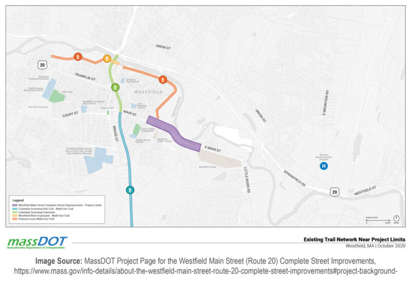
This project has been prioritized by the Massachusetts Department of Transportation (MassDOT), because the corridor was identified as having a high potential for daily walking and cycling. The corridor runs along Route 20/Main Street. As stated by MassDOT, “The purpose of this project is to improve pedestrian safety, transit accommodations, and provide connectivity for people walking and cycling on existing and planned shared use paths and trails in Westfield, MA.”
Process and people
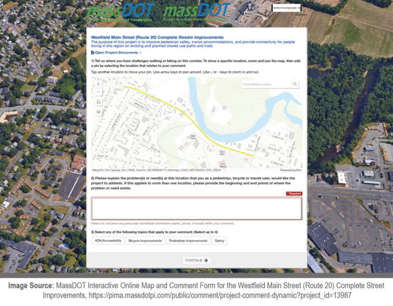
This project is being led by the MassDOT Highway Division. As of November 2021, the project team is currently gathering online feedback from stakeholders. An image from this information gathering process is shown. An interest in feedback related to accessibility and the Americans with Disabilities Act (ADA) is mentioned specifically. In terms of the types of outcomes that can be expected from the project, these include better connections between travel modes, vehicles travelling at slower speeds, and the addition of sidewalks—currently the corridor has a sidewalk on only one side of the roadway.
How this project could improve the complete trip
- By asking for the input of people living in Westfield, the project team should be able to gain valuable information about which parts of the Route 20/Main Street corridor would benefit from complete street upgrades.
- Based on the project documentation, it appears that pedestrian, cyclist, and transit user safety along the corridor should improve as a result of the project. By considering the personal requirements of these groups, the surrounding environment could be better designed for safety taking their input into account. By improving safety, the feasibility of pedestrian, bike, and transit journeys in the area should be improved.
- The complete trip components that appear to be involved include:
- Travel modes such as walking, cycling, and transit.
- Physical infrastructure to be determined but could take the form of redesigned intersections and signaling, sidewalk additions and repairs, bike lane upgrades, and other measures.
- Governance infrastructure may be considered on this project in addition to physical infrastructure. MassDOT announced grant availability of $12.5 million for “Shared Streets and Complete Streets” in July 2021. Massachusetts also has a Complete Streets Funding Program; in order to be eligible, municipalities must have a Complete Streets policy in place and develop a plan for prioritizing such projects. While funding is a significant supportive measure, Smart Growth America tracks a wide range of governance-related efforts across the country for Complete Streets through its “policy atlas.” These efforts include resolutions, policies, laws/ordinances, plans, design manuals/guides, internal policies/executive orders, and tax ordinances. A number of municipalities within the Springfield, Massachusetts MSA are identified on the Complete Streets “policy atlas” as having governance-related efforts in place.
- The end-to-end journey segment impacted for this project is the “core trip” segment between the depart from origin and arrive at destination milestones or between the enter/begin use of vehicle and exit/end use of vehicle milestones, depending on the travel mode.
Bus stop and sidewalk upgrades in the Portland, Oregon metropolitan area
Place and purpose
A bus stop and sidewalk improvement project in the Portland, Oregon metropolitan area, including some bus stops along a highway, succeeded in providing ADA-compliant features while enabling all transit customers travelling in high-traffic areas to get to bus stops more safely. The project also seems to have contributed to some ADA paratransit customers being more able to use fixed-route options in places where the bus stop upgrades were completed, instead of using paratransit only.
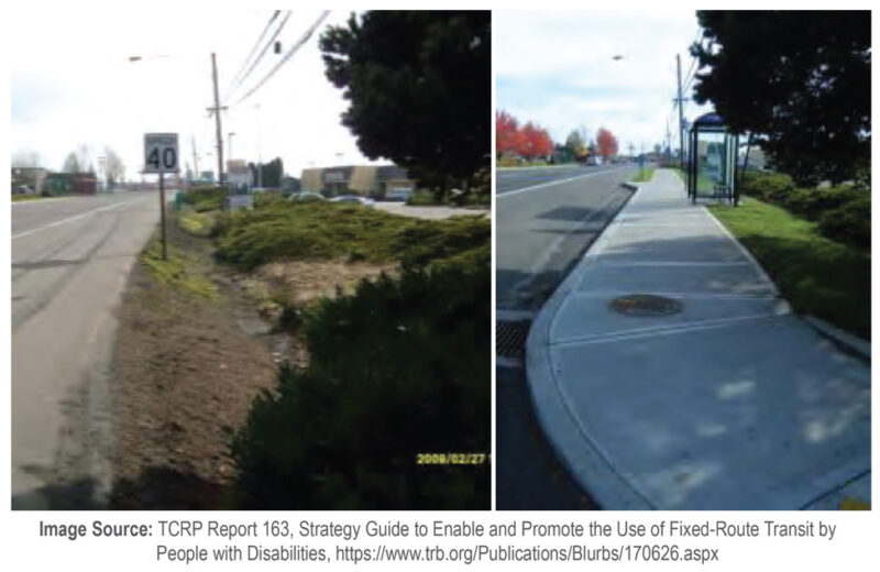
This project was led by TriMet, a local public transit agency. In 2008, TriMet completed project implementation, in partnership with the Oregon Department of Transportation (ODOT), of substantial upgrades to 17 bus stops and nearby sidewalks along a high-ridership fixed-route transit corridor in the TriMet service area. Some bus stops were located along a highway. The overall purpose was to increase safety for transit customers as they access bus stops. The project also focused on additional outcomes for customers with disabilities.
Process and people
This project, a collaboration between TriMet, ODOT, and local authorities in charge of sidewalk management, involved the construction and repair of sidewalks alongside the 17 bus stops that were missing or in disrepair. In addition, ten bus shelters were added, and concrete pads were constructed. Figure 10 provides before and after photos of one of the bus stops.
After the implementation of the project, TriMet conducted an assessment of its results. Of interest to TriMet was a multi-modal understanding of how the upgrades influenced the ridership of customers with disabilities—not only for fixed bus routes, but also ADA paratransit within a .25-mile radius of the upgraded bus stops.
The usage of fixed bus routes by customers with disabilities was tracked by TriMet. TriMet used the deployment of a lift on a fixed bus route as an indicator that a customer with a disability took a trip. In the year following the upgrades (from fall 2008 to fall 2009), lift deployments nearly doubled. In order to track the usage of ADA paratransit, TriMet used paratransit trips taken by customers with “conditional eligibility” as an indicator. Conditional eligibility is applied when “an individual may be able to use the fixed route system for some trips. Transit agencies can establish conditional eligibility for those individuals, and would only be obligated to provide complementary paratransit for those trips that the individuals cannot make using fixed route, based on the conditions of the particular trip.”
TriMet found that when comparing the year 2011 to the year prior to making the upgrades, paratransit ridership by conditionally eligible customers decreased by 12%. TriMet also found that there was no change during the same time period for fully eligible paratransit customers taking paratransit; bus stop upgrades did not appear to have a measurable impact on fixed-route bus ridership by fully eligible paratransit customers. Explained in TCRP Report 163, Strategy Guide to Enable and Promote the Use of Fixed-Route Transit by People with Disabilities, regarding this outcome, “it is conditionally eligible riders who will most benefit from stop and infrastructure accessibility improvements, as these are the riders who are able to use fixed-route transit in some cases. Regarding costs, if one assumes that the new lift/ramp trips at the 17 bus stops can be attributed to the improvements, and that without the improvements those trips would be on TriMet’s ADA paratransit service, then TriMet is saving nearly $60,000 per year by accommodating additional lift/ramp-using riders on fixed-route transit as a result of the improvements installed in 2009 (using the FY 2012 operating cost per ADA paratransit trip of $29.87).”
One takeaway from the TCRP report that may be of interest to other transit agencies is that a cost-benefit analysis could be conducted to compare the implementation of bus stop accessibility projects against the cost of providing additional ADA paratransit trips for those who are conditionally eligible; the costs of the latter might become reduced if projects such as the former are implemented—and could incur lower overall costs to the agency over time.
It is important to note that, due to the limitations of the data indicators used, the ridership patterns of customers with disabilities who do not need to use the lift, such as those with vision impairments, were not tracked. In short, it is possible that the benefits of the project were further-reaching than was quantified in TriMet’s analysis.
How this project could improve the complete trip
- Based on the project documentation, it appears that transit user safety, for customers with disabilities in particular, to the 17 bus stops should have improved as a result of the project. The bus stops and the environment surrounding them was better designed for safety, which should also improve the feasibility of taking transit trips in the area.
- The complete trip components that were involved include:
- Travel modes such as walking and fixed-route transit.
- Collaboration in the form of TriMet, ODOT, and the local authorities in charge of sidewalk management working together to conduct analyses and address construction and maintenance needs.
- Physical infrastructure in the form of the construction and repair of sidewalks, additions of new bus shelters, and the addition of new concrete pads at bus stops.
- Governance infrastructure potentially in the form of modifications to conditional eligibility agreements between TriMet and ADA paratransit customers. As TriMet makes significant upgrades to its bus stops and the areas surrounding them, it may lead to conditionally eligible paratransit customers no longer being eligible, at least in areas where fixed bus routes have been made more accessible.
- The end-to-end journey segments impacted are the segments between the depart from origin and enter vehicle milestones and exit vehicle and arrive at destination milestones for fixed-route transit.
Chapters
Related:

A Framework for Making Successful Technology Decisions
This guidebook aims to help you change your viewpoint by offering a framework for successfully articulating your operational needs, assessing whether technology can be part of a solution to them, and evaluating options.