Digital Tools to Facilitate Complete Trip Planning Digital Tools and the Complete Trip
- Date: February 3, 2023
Jump to section
The focus of the Guidebook is on how digital tools can aid in facilitating the complete trip and, within that, primarily the role that trip planning plays. Digital tools, as an element of technology infrastructure, operate within a wider framework of other types of complete trip components including physical, service, and governance infrastructure. Therefore, while focusing on digital tools and technology infrastructure, it is important to always consider how they will interact within the wider framework.
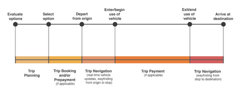
While the Guidebook primarily deals with digital tools for trip planning, it is important to keep in mind that trip booking, trip payment, and trip navigation functions are often tightly connected to trip planning. For this reason, the Guidebook does not exclusively deal with trip planning alone; it makes mention of trip booking, payment, and navigation functions as relevant. As shown below, the end-to-end journey milestones and segments correspond to typical functions supported by digital tools—trip planning, booking, payment, and navigation.
Trip Planing vs. Trip Planner vs. Trip Plan
For the purposes of this Guidebook, three terms will be used:
- Trip planning – General reference to the process of preparing to take a trip on one or more travel modes.
- Trip planner – Specific reference to map-based software applications that ingest data from one or multiple travel modes and produce itineraries from which users select the final trip plan to take. Decision-making criteria typically displayed within trip planners include time (i.e., trip duration), cost (i.e., total trip cost), and distance (i.e., total distance to cross), though other factors may be included.
- Trip plan – Specific reference to the itinerary for the selected trip.
Trip planning is a process that may or may not involve digital tools. Section 1.3 of the Guidebook refers to a “mental calculation” that all mobility system users perform to some extent, especially when embarking on a new mode. This process involves evaluating different options, by anticipating the travel experience and considering criteria (e.g., time, cost, and safety), and finally, selecting an option. These activities help to describe the process of trip planning. Prior to the availability of digital tools such as trip planning apps and websites, people performed these calculations mentally if the travel modes and options warranted consideration. They simply had less precise information at their fingertips in order to do so.
With the advent of trip planners, mobility system users have been given a digital tool to aid in their mental calculation. Users of trip planners are typically able to organize information better than they could otherwise from a mental calculation alone. Take the Google Maps transit trip planner, for example. By having information on all the streets and their dimensions, the estimated walking time to the bus is likely much more precise in Google Maps than through a mental calculation. Some trip planners even have information on calories expended, so that decisions can be made according to exercise potential.
Some of the most common trip criteria that people consider are cost and time; both of these tend to be well estimated in current trip planners as of November 2021. Other criteria that are commonly considered—but are not necessarily easy to assess in trip planners—are safety and comfort. While much of the transit industry’s energy is put into improving the safety of getting to and taking transit, transit customers using trip planners and other digital tools still typically need to perform a personal safety assessment through their own mental calculation.
This is, in part, why section 1.3 of the Guidebook gives so much attention to how people go about determining the feasibility of the journey. Assessing personal requirements for a travel mode, safety in particular, is indeed a personal process that involves a number of factors including a person’s past experience, their own appetite for risk, and the information they have at hand—all contributing to their perception of the experience.
There are, at present, no trip planners that allow for all safety-related information to be considered at one time. There are some digital tools that have pieces of safety-related information, but the information overall is incomplete. To check the street and intersection conditions for a pedestrian trip in an unfamiliar area in the US, the best way to gain information is often to check Google Street View. Though this is a helpful digital tool, the information it provides is still just one input into a broader and more complex mental calculation an individual performs to consider their personal requirements. The reality of this situation is that people live with a great deal of ambiguity in the trip planning process.
In short, trip planning is a complex process supported by mental calculations with the aid of trip planners and other digital tools. Trip planners are certainly helpful in reducing uncertainty for some decision-making criteria in the trip planning process; at the same time, they have their limits.
Introduction to Projects and Initiatives
In order to provide context around how digital tools can support the complete trip for various travel modes, a table is provided in section 2.3 with information on projects. Each project is framed in terms of the journey segment with which it most closely aligns. By considering how each segment is supported through digital tools, it becomes clearer how the complete trip, as a whole, can best be supported.
In addition to the table in section 2.3, there are also four highlighted projects provided in Section 2.4, allowing for greater detail to be covered. Section 2.5 explains how specific types of initiatives can support the adoption of new digital tools for the Complete Trip. These initiatives include practices for using multiple tools together, innovative procurement processes, and embarking on General Transit Feed Specification (GTFS) data creation and maintenance projects.
For transit agencies considering their own approaches, these projects and initiatives provide valuable examples. Mobility professionals can adopt multiple digital tools, or a single tool that supports multiple functions, to support a) the travel modes that are present in their system, b) the journey segments most in need of support, and c) the personal requirements of individuals. Through these examples, mobility professionals can see how digital tools can improve the customer experience for each journey segment as well as the complete journey.
Key Topics
There are a number of data and technology-related trends referenced throughout the projects and initiatives. While this list is not exhaustive, information on key topics provides an informational base that is needed to understand some of the project details.
GTFS Data and Extensions
The General Transit Feed Specification (GTFS) is a data specification that began as a way to communicate static fixed route transit schedules and routes, primarily used in trip planners. On that foundation, extensions have been added over the years that impact GTFS data, such as GTFS-RT (real time) which can now show real-time route details based on the location of vehicles, as opposed to relying on static schedule data alone, thus improving the accuracy of trip planners. GTFS-RT can also be used on a stand-alone basis to display wait times for approaching vehicles. Other extensions include GTFS-flex, which displays flexible transit options such as demand-response transit, flag stops, and route deviations. There are also emerging areas for GTFS, such as GTFS-eligibilities and GTFS-pathways. The former enables services that have eligibility requirements such as age, veteran status, or disability to be displayed with relevant details, while the latter provides navigation details that are important to customers with disabilities. GTFS and its extensions are commonly used across the US and the world to standardize transit information, so that apps and other services, once developed, can more easily support users across the globe. More details on GTFS-related efforts are provided in N-CATT’s Data Practices Guidebook; the table on “Important Transportation Data Specifications” in a Shared-Use Mobility Center (SUMC) case study provides further detail on GTFS and other data standards.
Open Trip Planner
Open Trip Planner (OTP) is an open source software that has provided a code base for a few of the projects explained in this chapter. To learn more about open source software and open data, see the N-CATT white paper, “Open Source Software and Open Data: What Are They and How to Use Them.” As explained on the OTP website, “OTP is an open source multi-modal trip planner, focusing on travel by scheduled public transportation in combination with bicycling, walking, and mobility services including bike share and ride hailing… It builds its representation of the transportation network from open data in open standard file formats (primarily GTFS and OpenStreetMap). It applies real-time updates and alerts with immediate visibility to clients, finding itineraries that account for disruptions and service changes… As of 2020, the codebase has been in active development for over ten years, and is relied upon by transportation authorities and travel planning applications in deployments around the world.”
On-Demand Transit/Microtransit
On-demand transit/microtransit is a travel mode that has become more common over the past five years as an option provided by transit agencies. Once transportation network companies (TNCs) such as Lyft and Uber became more common, it also became clear in the transit industry that the type of technology TNCs use could have broader implications. By connecting the geolocation in mobile phones, which identifies a transit customer’s location, with the automatic vehicle location (AVL) data that identifies a transit vehicle’s location, more dynamic trips can be provided that are available in near real time across service areas that have no fixed routes. This is in striking contrast to demand-response transit services, which typically require trip booking and reservations to be handled the day prior to the travel day due to limitations of the enabling technology.
Since on-demand transit/microtransit service is built around the core technology of dynamic route scheduling, a complex software that relies on real-time customer and vehicle locations, the customer processes of trip planning, booking, payment, and navigation are typically handled within a single platform or app that interfaces with the core technology. In its current iteration, this often results in on-demand transit not being displayed as an option within multi-modal trip planners. Instead, it is more common for the digital components of this mode to be handled by customers in a separate, dedicated app. More details on how on-demand transit works are provided in the N-CATT Guidebook, New Software Adoption for Small Transit Agencies. Other resources that help explain this topic include TCRP Synthesis 141, Microtransit or General Public Demand–Response Transit Services: State of the Practice, SUMC’s Learning Module on Microtransit, and a list provided by APTA of various microtransit projects.
While on-demand transit/microtransit is generally supported within a single app for booking and payment, it is sometimes possible to connect these platforms with a broader multi-modal trip planning application as has been done in the Denver metro area.
Highlighted Projects
Below is a list of projects worth noting from around the country. Following this list are profiles of a select few of these projects.
Multi/intermodal
- Intermodal Trip Planner in Portland, OR
https://learn.sharedusemobilitycenter.org/overview/trimet-trip-planner-adds-uber-share-now-and-biketown-portland-oregon-2019/ - Intermodal Trip Planner in Vermont
https://nationalcenterformobilitymanagement.org/resources/oc-oc-state-of-vermont/
https://govermont.agilemile.com - Intermodal Trip Planner and Navigator in Helsinki, Finland
https://www.cerema.fr/system/files/documents/2020/04/cerema_parangonnage_maas_synthesis_eng.pdf - Intermodal Trip Planner and Navigator in Pinellas County, FL
https://learn.sharedusemobilitycenter.org/overview/psta-partners-with-the-transit-app-pinellas-county-fl-2017/
Walking
- AccessMap in Seattle, WA
https://www.washington.edu/news/2017/02/01/new-route-finding-map-lets-seattle-pedestrians-avoid-hills-construction-accessibility-barriers/ - Accessibility Mapping Project for the University of Pennsylvania
https://web.sas.upenn.edu/access-map/ - Open Sidewalks Project
https://www.opensidewalks.com - Project Sidewalk
https://www.washington.edu/news/2019/04/18/project-sidewalk/
Cycling
- Komoot Trip Planner and Navigator
https://www.komoot.com - Ride with GPS Trip Planner and Navigator
https://ridewithgps.com - Strava Trip Planner and Navigator
https://www.strava.com
Micromobility
- Adaptive Bikeshare Pilot in Oakland, CA
https://learn.sharedusemobilitycenter.org/overview/ford-gobike-adaptive-bikeshare-pilot-oakland-california-2019/ - Adaptive Micromobility Vehicles with Lime
https://learn.sharedusemobilitycenter.org/overview/lime-seeks-to-provide-new-adaptive-vehicles-new-york-new-york-2021/ - Bikeshare Program in Pocahontas, Northwest IA
https://learn.sharedusemobilitycenter.org/overview/small-bikeshare-system-launched-in-pocahontas-northwest-ia-2018/ - Bikeshare System Expansion into Adaptive Bikes in Milwaukee, WI
https://learn.sharedusemobilitycenter.org/overview/milwaukee-incorporates-adaptive-bikes-into-public-bikeshare-system-milwaukee-mi-2019/ - E-Scootersharing Program in Burlington, IA
https://learn.sharedusemobilitycenter.org/overview/bird-launches-e-scootersharing-program-burlington-ia-2021/
Fixed-route transit
- Multi-modal trip planner in Tulare County, California
https://www.transitwiki.org/TransitWiki/index.php/GTFS-flex#Tulare_County.2C_California - Step-Free Trip Planning in Chicago, IL
https://www.transitchicago.com/planatrip/accessiblegoogletrip/ - Trip Planner with Bus Stop Accessibility Details in Washington, D.C.
https://www.wmata.com/schedules/trip-planner/
https://www.wmata.com/service/accessibility/metrobus.cfm - Wheelchair-accessible Trip Planning in Boston, MA
https://medium.com/@karti.subramanian/investing-in-accessibility-technology-pays-off-for-mbta-riders-f555c1b0456e
https://techcrunch.com/2018/03/15/google-adds-a-wheelchair-accessible-option-for-transit-maps/ - OneBusAway app for Real Time Transit Info
https://onebusaway.org - Integrated trip payment in Denver, CO
https://learn.sharedusemobilitycenter.org/casestudy/denver-rtd-and-uber-app-development/ - Multi-Agency Mobile Ticketing in Ohio
https://www.apta.com/ohio-neoride-ezfare/ - Trip payment in Gwinnett County, GA
https://atltransit.ga.gov/xpress-and-gwinnett-county-transit-launch-token-transit-mobile-ticketing-program-to-help-prevent-the-spread-of-covid-19/ - Wayfinding for individuals with vision impairments/blindness in Kansas City, KS and MO
https://ridekc.org/rider-guide/navigator
Demand-Response/Paratransit/HST
- HST Trip Coordination in Denver, CO
https://nationalcenterformobilitymanagement.org/resources/oc-oc-denver-metro-area/ - Online Booking for Paratransit in Orlando, FL
https://nationalcenterformobilitymanagement.org/resources/oc-oc-central-florida/ - On-Demand Paratransit Pilot Program in Boston, MA
https://learn.sharedusemobilitycenter.org/overview/on-demand-paratransit-pilot-program-boston-massachusetts-2016/ - On-Demand Paratransit Pilot Program in Kansas City, KS and MO
https://learn.sharedusemobilitycenter.org/casestudy/ridekc-freedom-on-demand-pilot-leveraging-existing-contracts-for-on-demand-paratransit/ - Online Booking Tool for Paratransit in Las Vegas, NV
https://learn.sharedusemobilitycenter.org/overview/transportation-agency-launches-online-booking-tool-for-paratransit-las-vegas-nv-2021/ - Paratransit Mobility on Demand Demonstration in Pinellas County, FL
https://learn.sharedusemobilitycenter.org/overview/paratransit-mobility-on-demand-demonstration-pinellas-county-florida-2017/
On-demand transit
- On-Demand Transit Pilot in Johnson County, KS
https://n-catt.org/resources/emerging-transit-tech-connecting-low-density-regions-through-microtransit/ - On-Demand Transit Pilot in Traverse City, MI
https://learn.sharedusemobilitycenter.org/casestudy/modernizing-mobility-on-demand-at-bata-traverse-city-mi/ - On-Demand Transit Program Expansion in Dallas, TX
https://learn.sharedusemobilitycenter.org/overview/dart-microtransit-program-pilots-service-in-new-area-dallas-tx-2021/ - Rural On-Demand Transit Pilot in Gloucester and Wise Counties, VA
https://learn.sharedusemobilitycenter.org/overview/rural-virginia-transit-agencies-pilot-microtransit-services-gloucester-and-wise-counties-va-2021/
Intermodal Trip Planner in Northwest Oregon
Place and Purpose
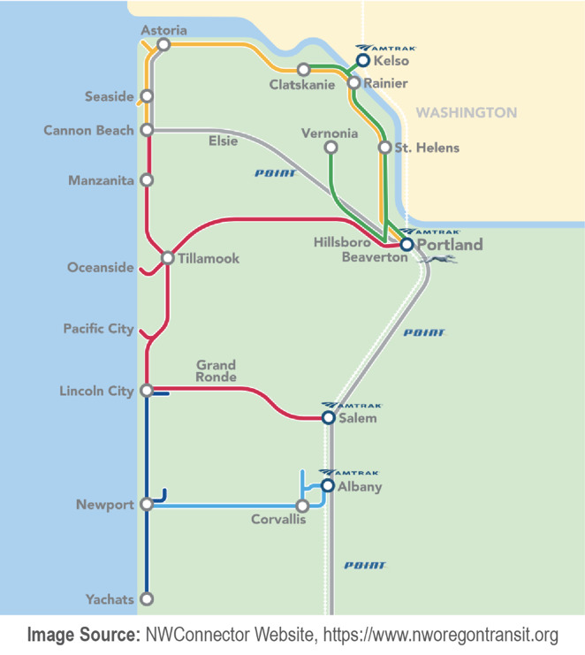
This project, based in Northwest Oregon, includes cities along the coast of Oregon as well as the Portland metro area, Corvallis, Albany, and Salem. More details are shown on the map below. The project is led by the NW Connector, a coordinated regional transit system, including five transit agencies in Northwest Oregon: Columbia County Rider, Sunset Empire Transportation District, Tillamook County Transportation District, Benton County Transit, and Lincoln County Transit. The partnership aims to “improve transit connections between northwestern Oregon communities, brand and market the NW Connector transit service in all five counties, build community partnerships to increase transit ridership while promoting regional business and economic development opportunities, and implement sustainable funding strategies for continued transit system development.”
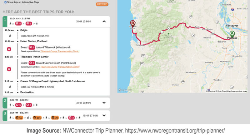
One project this partnership has implemented is the intermodal trip planner, which integrates both fixed-route transit, through GTFS data feeds, and demand-response transit (DRT), through GTFS-flex data feeds, into a single interface (screenshot below).
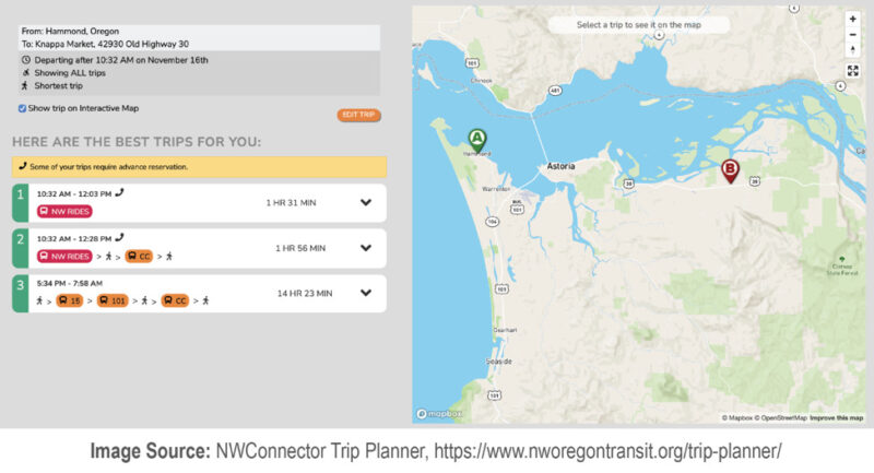
One example of local DRT service is NW Rides, provided by Tillamook County Transportation District (TCTD). As shown below, more information is provided for this DRT trip, “NW Rides is reserved for people who qualify for Medicaid insurance benefits and need transportation to and from their Oregon Health Authority (OHA) covered medical appointments. Call 503-861-0657 or 888-793-0439 at least 2 hours ahead of your desired trip to request a ride or to determine eligibility.” This particular option was displayed because the following checkboxes were selected, “include trips requiring reservations” and “include trips with eligibility requirements.” Other DRT services, such as TCTD’s Dial-A-Ride for the general public, do not have eligibility requirements but recommend advance reservations. As mentioned in the transcript for a GTFS-flex webinar provided by N-CATT, the NW Connector trip planning software is based on the Open Trip Planner.
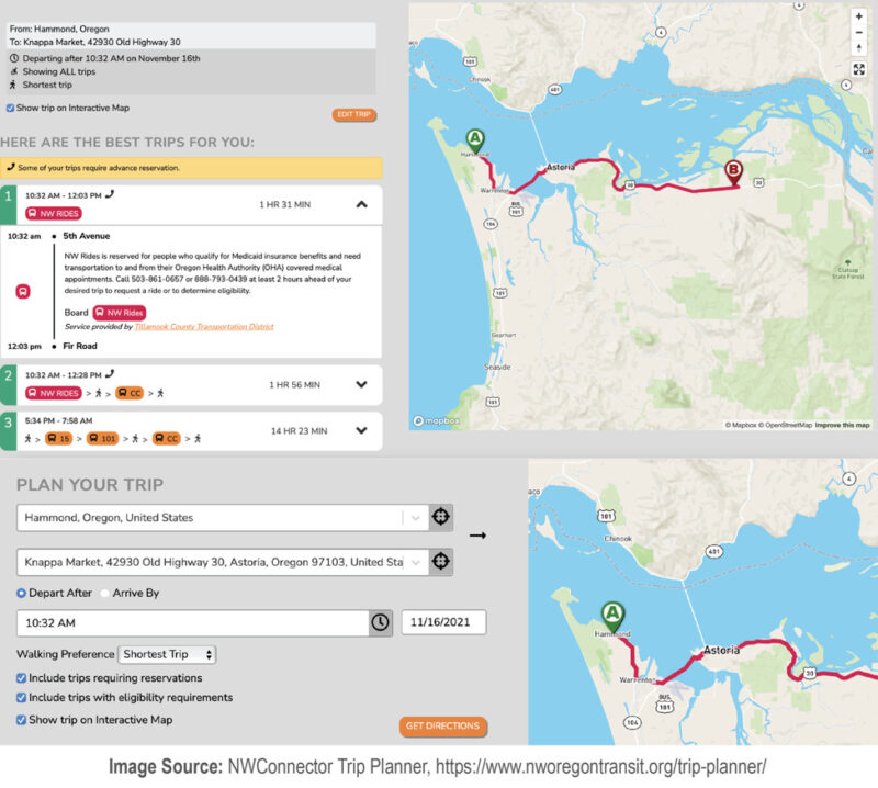
Trips are possible between the Portland metro area and the coast via fixed route options, such as the trip shown below. An interactive map is included with the trip planner to let the user know what services are available. On the interactive map, a “trip ideas” feature is included that highlights points of interest for the user such as wildlife refuges, parks, trails, and other places. On the “data and apps” page, it is mentioned that in addition to making all the data available to the public, the data have also been included in other trip planning platforms apps as Google Transit and Transit.
Process and People
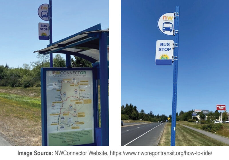
By forming an alliance, these five transit agencies have laid the groundwork for the kind of coordination needed to make their collective services most helpful to users. The group meets monthly to make decisions on route coordination, schedules, operations, and other regional needs. Visitor passes for three or seven days are available across all five agencies and have been designed especially for residents of the more urban areas such as Portland and Corvallis to travel to the coast. The alliance also has a joint policy on bicycle storage. As shown below, the bus stops have been equipped with the NW Connector brand, so that the system has a unified appearance even though there are five agencies providing the service. Agreeing on policies for joint fare payment, bicycle storage, and unified branding shows this partnership has an advanced level of governance in place.
How this project could improve the complete trip
- Based on the project documentation, it appears that as a result of the interactive trip planning project, transit users are more aware of the complete list of their transit options in Northwest Oregon. By including transit options that require the “include trips with eligibility requirements” and/or “include trips requiring reservations” items to be checked, the project team has designed a more usable trip planner that reflects a wider range of transit options than is typically shown in a trip planner. By widening the scope of the options shown, users can better compare their personal requirements with their travel options and arrive at a more optimal solution that works for them.
- The Complete Trip components that were involved include:
- Travel modes such as fixed-route transit, on-demand transit, and Americans with Disabilities Act (ADA) paratransit/human-services transportation.
- Technology infrastructure in the form of the interactive trip planner, a digital tool that ingests and displays GTFS and GTFS-flex data under the NW Connector brand. This tool communicates information about service areas, transit routes, and bus stop locations—elements of the physical and service infrastructure of the transit agencies—without fundamentally changing these elements on-the-ground.
- Physical infrastructure in the form of bus stops that have been equipped with the NW Connector brand. This reinforces that physical and digital experiences should have a similar feel. Once someone has used the trip planner with the NW Connector brand and then goes to a bus stop with the NW Connector brand, even though there may be multiple transit agencies providing the trip, the fact that the branding is consistent from the digital to the physical realm reinforces the feeling of a unified effort. It also reduces confusion for the transit user.
- Governance infrastructure and collaboration in the form of data/trip planner maintenance, unified branding, joint fare policies, and joint bicycle storage policies. Trip planners, once created, take significant work to keep up and running. The data sets must be updated and the trip planning platform must also be maintained, both of which require some sort of joint oversight when five agencies are involved—as is the case with this project. The same is true of unified branding across multiple agencies; some governance is required to set the standards and agree upon the look and feel of the branding products. The joint fare policies and joint bicycle storage policies help reduce confusion for the user; regardless of the agency they use, their bike will be treated the same. They also know if they purchase a joint transit pass from one agency, it will be accepted by the other. Unified efforts such as these require a great deal of behind-the-scenes work to present a public face.
- The end-to-end journey segment impacted by the intermodal trip planner is the segment between the evaluate options and select option milestones.
Bus stop accessibility map in Northwest Indiana
Place and Purpose
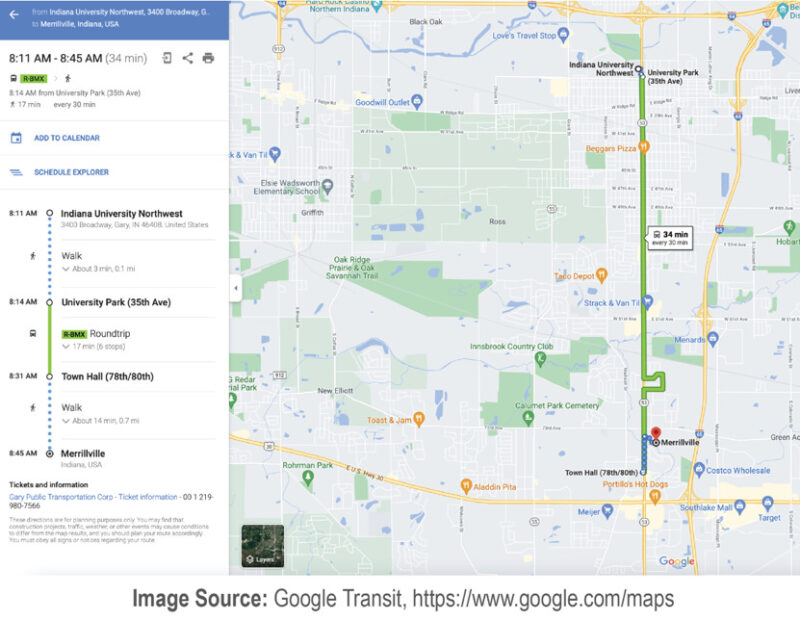
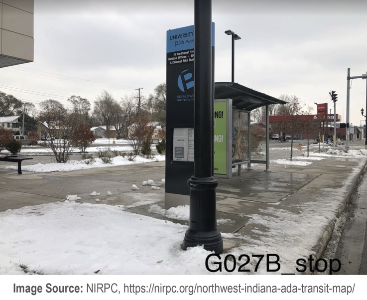
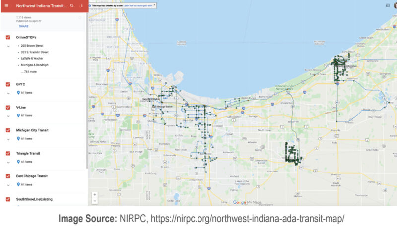
In May of 2021, the Northwestern Indiana Regional Planning Commission (NIRPC) launched an interactive online transit map, called the Northwest Indiana ADA Transit Map, to assist transit customers in northwestern Indiana with making decisions regarding which bus stop to use. This map supplements the trip planning process a customer with a disability would perform. As a first step, the customer would search for a trip as shown below since the region’s transit data are included in Google Maps in the GTFS format.
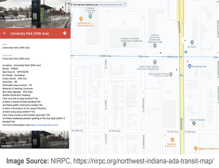
Once the bus stop that might be used is known, as a second step, the customer can review the details of that particular bus stop to assess if they would be able to navigate it safely and comfortably. Tools such as this help reduce the uncertainty that many people with disabilities encounter daily. By knowing what to expect, such customers can make decisions in advance during the trip planning process that better meet their needs. For this example, bus stop GPTC027B is being considered. As shown in the slider below, the customer can view the details of the stop and two pictures taken on-site. When compared with the Google Maps streetview image that is available, the NIRPC image is a significant improvement.

Trip planning can also work in the other direction with this bus stop accessibility map.
As a first step, a customer can locate a stop on the interactive map and then, as a second step, plan a route that starts or ends with the stop in Google Maps. After locating the arrow on the red banner beneath the photo, the user can click on it. This opens another Google Maps tab which puts the bus stop in the place of the trip destination, which can also be switched to the trip origin.
Process and People
This project represents a major undertaking. As stated in the press release, “NIRPC data analysts Peter Kimball and Kevin Polette traveled to each bus stop in Lake, Porter, and La Porte counties—a total of 561 locations—during 2020 to assess many criteria for the inventory.” The map is shown in Figure 23. Each stop has the following description: location information, physical characteristics, and amenity information; some stops include pictures of the stop and its immediate surroundings. A link to the transit agency providing the service is shown for each bus stop. N-CATT featured this project in Episode Two of its Season Two podcast.
The bus stops of eight transit operators in the region were included in the project: Gary Public Transportation Corp., East Chicago Public Transit, North Township Dial-a-Ride Opportunity Enterprises, Porter County Aging Community Services, City of Laporte Transit, Michigan City Transit, City of Valparaiso V-Line and Chicago Dash, and Lake County Community Services. Some of the agencies, such as Gary Public Transportation Corp. (GTPC) and East Chicago Public Transit leverage other apps to provide customers with even more trip planning options. On a GTPC webpage announcing Moovit and Token Transit apps, the following is stated regarding Moovit: “multimodal journey planning, coupled with mobile ticketing, will enable riders to easily plan, pay, and ride on Gary Public Transportation Corporation, The South Shore Line, East Chicago Transit, Chicago-area transit and beyond.”
How this project could improve the Complete Trip
- Based on the project documentation, it appears that as a result of the bus stop accessibility map project, transit users with disabilities will have significantly improved trip planning information in Northwest Indiana. By considering the types of bus stop information an individual with a disability might need to assess if a bus stop meets their personal requirements, NIRPC has enabled transit users with disabilities to make much more informed decisions regarding their transit trips—possibly shedding light on bus stops that offer greater levels of safety and comfort which could increase the feasibility of trips.
- The Complete Trip components that were involved include:
- Travel modes such as walking and fixed-route transit.
- Collaboration in the form of digital tool maintenance. Since the bus stops of eight transit operators in the region were included, NIRPC would likely need to work collaboratively with the transit agencies to maintain this tool—updating it as conditions on-the-ground at the bus stops change. The joint work to keep such a tool updated would generally involve some level of oversight.
- Technology infrastructure in the form of the bus stop accessibility map, a digital tool that displays details about bus stops for transit users with disabilities during the trip planning process. This tool communicates about bus stops—an element of the physical infrastructure of the transit agencies—without changing the actual physical infrastructure.
- The end-to-end journey segment primarily impacted is the segment between the evaluate options and select option milestones. If the tool were applied further once the user departed from their origin during transit trips, then it could also impact the segments between the depart from origin and enter vehicle milestones as well as exit vehicle and arrive at destination milestones.
Rural transit coordination in Lake County, Oregon
Place and Purpose
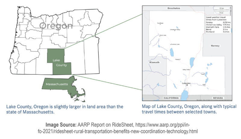
Lake County, located in the southcentral area of Oregon is classified as a “frontier” area, which is the most rural in the classification system for the United States; the rural categories include “rural,” “highly rural,” and “frontier.” With a population of approximately 7,895 and a land area slightly larger than the state of Massachusetts, the population density is extremely low.
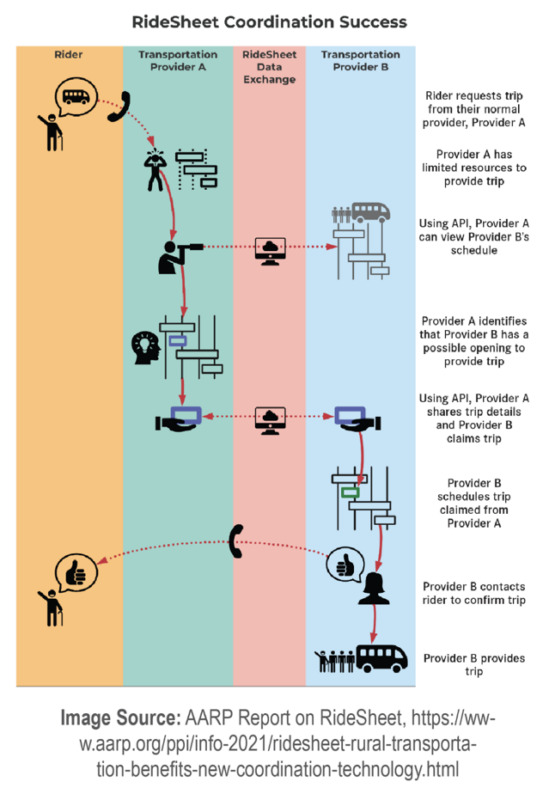
In Lake County, there are very few mobility options outside of driving one’s own vehicle. There are no taxi companies or TNCs in operation, and in terms of public transit, there are two providers—both of them non-profit organizations providing demand-response transit (DRT). These two organizations, Inner Court Family Center (ICFC) and Lake County Senior Center Association (LCSCA), embarked on the “RideSheet” rural transit coordination project to enable one organization to quickly check with the other one when there was difficulty providing a ride—essentially coordinating their services for the benefit of customers. Since they are the only two transit providers in the county and their service areas overlap, they have many of the same customers in common.
This project does not involve an explicit trip planning component. Since local residents have such limited options in Lake County; transit customers likely move straight into trip booking with the organization that has a service area most closely aligned with their trip needs. This project helps significantly with the trip booking process for these customers. Instead of the customer being denied a trip with one provider and then contacting the other provider to find out if they can handle the ride instead, the providers coordinate this activity among themselves—providing a much more customer-friendly service. As explained by the National Aging and Disability Transportation Center, “…while the mechanics of the software happen behind the scenes, riders benefit directly. Riders gain more opportunities to travel as regional providers come to rely on one another when their own vehicle and driver capacity is constrained. Tapping this capacity won’t require any additional phone calls or website logins on the part of the rider. They simply make their request for a ride through their preferred provider and the system is set up to serve them. Ultimately, the rider could end up paying less for a ride if the system finds enough riders to share a given trip.”
The primary purpose of the project for the transit service providers, ICFC and LCSCA, was to achieve greater operational efficiency. Prior to the RideSheet project, the agencies coordinated trips through emails and phone calls, and scheduled the routes by hand. After the RideSheet project, the agencies coordinate trips and schedule the routes through the new software—which should save significant time after staff members become accustomed to the new way of working. The primary purpose of the project for transit customers is to simplify the trip booking process; they can contact one provider to access the resources of both transit providers.
Process and People
ICFC and LCSCA had been coordinating with each other prior to the RideSheet project, but their coordination processes were mainly paper and phone based. The RideSheet project enabled the organizations to try out a more automated way of coordinating trips—for both scheduling the trips across the two providers and generating demand-response routes—by using applicable software. The graphic in the opposite column illustrates how the joint scheduling process works across the two providers.
Other project innovations include leveraging the “transactional data specification,” assistance with trip data tracking, and generating the routes for vehicles to take. As explained in the AARP RideSheet project brief, “RideSheet was programmed to use the transactional data specification (TDS) as defined by Transit Cooperative Research Program’s (TCRP) Report 210, Development of Transactional Data Specifications for Demand-Responsive Transportation. By making sure that RideSheet follows the structure established in the TDS, the project follows a best practice for data management.” RideSheet also automates the process of tracking the various details of trips taken; these data are required for reporting processes and are shared with funding organizations. In addition to enabling the sharing of route details between the transit providers, so they can see if there is capacity to add additional passengers, the software also generates the routes for vehicles to take, referred to in the project brief as a “run.”
AARP funded this effort in 2020 and enlisted consulting support to create the custom software. The software consulting team, Full Path LLC, worked with ICFC and LCSCA, as well as Lake County, during 2020 to understand their processes and the results they required. Full Path LLC sought to provide a “lightweight” software solution that did not require staff to spend too much time learning a complex product.
The open-source software was made available in early 2021 and is free to use for other transportation providers with similar needs. Although the software is custom, it was designed with the needs of similar agencies in mind. AARP is interested in both the TDS and RideSheet being more widely used.
How this project could improve the complete trip
- By working directly with the transit service providers, Inner Court Family Center (ICFC) and Lake County Senior Center Association (LCSCA), the project team was able to gain valuable information about how the software could improve the joint operations of these organizations while also simplifying the trip booking process for the customers.
- Based on the project documentation, it appears that operational efficiency and the customer trip booking process should have improved as a result of the project.
- The Complete Trip components that were involved include:
- Travel modes such as demand-response transit (DRT).
- Collaboration between AARP, Full Path LLC, ICFC, LCSCA, and Lake County—foundational for the research and implementation of this project. Even if there is no formal written document about how they should work together, by taking part in this project and using the software day-to-day, ICFC and LCSCA have committed to significant coordination between their two operations.
- Technology infrastructure in the form of the RideSheet software, a digital tool that helps providers of rural transit coordinate their services. This tool communicates about the service infrastructure—the planned routes and trips requested—without fundamentally changing them.
- The end-to-end journey segments impacted are those between select option and exit vehicle + arrive at destination milestones for DRT.
On-demand transit in Tompkins County, New York
Place and Purpose
Tompkins County in New York state is served by Tompkins Consolidated Area Transit (TCAT). In the center of Tompkins County is Ithaca, which includes Cornell University and Ithaca College. Outside of Ithaca, which has a population of around 30,000, Tompkins County is less densely populated and is characterized by areas that are more rural.
As explained in the previous case study, advances in technology have made on-demand transit service a modal option for transit agencies. TCAT realized that fixed-route transit service may not be financially viable for parts of the county with sparser population patterns. Beginning in 2020, TCAT began providing an on-demand transit service for Lansing and Etna and then in 2021, expanded the on-demand service area to Freeville and Dryden. These areas, Lansing, Etna, Freeville, and Dryden, were previously underserved with public transit options. TCAT considered on-demand transit a cost-effective way to expand the reach of the services the agency provides the county. In addition to helping the residents of Lansing, Etna, Freeville, and Dryden travel around the area, it also helps these residents reach the densest part of Tompkins County—Ithaca and its immediate surroundings.
Leveraging on-demand transit to provide entirely new transit service to previously underserved areas is one potential purpose for on-demand transit. For the sake of comparison, there are agencies who leverage on-demand transit to bring existing demand-response service into a new era of technology—moving from a typical requirement of day-prior booking to accepting more immediate trip requests such as 30 minutes prior to taking the trip. By moving forward with the newer technology, it is possible to serve the same service area in a manner that is more convenient for customers—which may enable more trips to be taken by expanding the possibilities into more spontaneous travel. One example of an agency who pursued on-demand transit for this reason is Traverse City, Michigan. They moved from an existing “dial-a-ride” demand-response service to on-demand service in 2020. In less common cases, transit agencies have shifted their fixed-route transit service to on-demand service. This is the case in Hall Area Transit Services in Hall County, Georgia with its WeGo service.
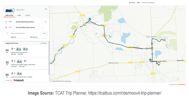
Trip planning, trip booking, and sometimes trip payment for on-demand transit is typically handled entirely through an app dedicated to the on-demand service, as explained in previous cases. Considering the state of the practice for multi-modal trip planners, it is uncommon to find on-demand transit as an option in such apps. Take, for example, Tompkins County. A TCAT webpage lists a few trip planning apps including Moovit, Transit, and Google Maps. One trip planner featured on TCAT’s website, embedded within a dedicated trip planning page, is Moovit. When a trip is planned within the Freeville and Dryden service area, which TCAT serves with on-demand transit, only fixed-route bus options come up as shown in Figure 26. This seems to imply that on-demand options are not included within the trip planner. Generally, such options are not intentionally excluded; more commonly the software does not enable the data for such options (such as GTFS-flex) to be added, and therefore, they are not displayed. The section which covers the “intermodal trip planner” project in Northwest Oregon, showcases a trip planner that does enable on-demand and demand-response options to be included alongside fixed-route transit options. The Oregon trip planner is based on the Open Trip Planner (OTP) open source software, which includes demand-response as well as many other trip options.
Process and People
TCAT’s on-demand service, called Tconnect, includes two separate service areas that do not connect with each other directly; one includes Lansing and Etna and operates on the weekends, while the other includes Freeville and Dryden and operates on weekdays. Transfers from Tconnect to TCAT’s fixed-route service are free. The Lansing-Etna service connects to TCAT’s Route 30, and the Freeville-Dryden service connects to TCAT’s Route 43—both routes providing service to/from downtown Ithaca and Cornell. In establishing this service, TCAT explains their intent is to “target geographic areas with so-called ‘transit deserts,’ or low-density residential pockets that don’t have enough demand to cover the high cost of fixed-route transit, but yet enough population to merit a less-costly on-demand service. These types of services can be life changing, especially for low-income households that struggle to find transportation to work and to obtain basic services.” TCAT explains that an important aspect of Tconnect is the “use of smaller buses, which are far less costly to operate than the typical 40-foot, large-capacity bus typically needed for fixed-route service. The Tconnect service in the Lansing-Etna area is being operated by TCAT drivers using TCAT’s small cutaway 30-foot, 29-passenger buses. The Dryden service will use Gadabout drivers and Gadabout’s 18-foot, 10-passenger buses. In addition to being less expensive to operate, smaller buses are easier for drivers to maneuver on rural roads.”
Customers use the HyperCommute app, provided by Urban Mobility Inc., to plan and book Tconnect trips. As an alternative, customers can also book trips over the phone. TCAT explains this option, “We recognize that some would-be riders do not have access to a mobile device, or choose not to have a data plan and we are more than happy to accommodate anyone in those situations.” In addition, TCAT provides guidance to customers who would like to use the app, but do not know how. “For those who would like app training and/or additional information, Tconnect team members will be conducting outreach and welcome would-be riders to contact them for app training or to answer any questions about the service. To request assistance or a meeting, email team members…” This is a best practice in providing on-demand services; there is often a gap that can be bridged by teaching customers who are less accustomed to apps of this type on how to use the app in a group-based or one-on-one setting. TCAT has also provided an online video on how to use the app, also a best practice.
Tconnect is a joint effort with multiple funding sources. As explained in the SUMC article, “Tconnect Microtransit Service Expands to Dryden, NY 2021,” TCAT “developed Tconnect in partnership with Way2Go, a program under the Cornell Cooperative Extension of Tompkins County, and is financially supported by grants from the New York State Energy Research and Development Authority (NYSERDA) and the Federal Transit Administration’s Integrated Mobility Innovation program.”[9] With two years of funding that should run through 2023, the project team has set up an ideal situation that allows for a few years of operating the service with the potential to scale up operations.
How this project could improve the Complete Trip
- Based on the project documentation, it appears that transit options for customers previously living in so-called “transit deserts” have been expanded as a result of the project. By considering the personal requirements of customers living in low-density areas, TCAT seeks to address the gaps in transit service that these customers experience.
- The Complete Trip components that were involved include:
- Travel modes such as on-demand transit.
- Collaboration between TCAT and the Cornell Cooperative Extension of Tompkins County, which contributed to the project.
- Service infrastructure in the form of a new on-demand service called Tconnect.
- Technology infrastructure in the form of the HyperCommute app and accompanying software that assists TCAT in generating dynamic on-demand routes. The HyperCommute app and TCAT’s website communicate about the service infrastructure including the on-demand service areas and service details.
- The end-to-end journey segments impacted are those between select option and exit vehicle + arrive at destination milestones for on-demand transit.
Transit Agency Initiatives
A few transit agency initiatives are explained to illustrate additional ways to support complete trip efforts.
Practices for using multiple tools together
As the project table in the previous section illustrates, some modes such as fixed-route transit benefit from leveraging multiple digital tools together to support various needs across the end-to-end journey. As explained in N-CATT’s Guidebook on New Software Adoption for Small Transit Agencies, “Whether an agency is acquiring multiple types of software to meet its needs or is adding a new type of software to its current software ecosystem, it is essential that it determine how much connectivity between the software applications will be needed. If the different software applications need to exchange data with one another, then the software must be ‘interoperable.’ When interoperability is necessary, the agency must ensure that its software acquisition process makes this a high priority in terms of the scope of the acceptable software solutions.” Chapter 1 and Chapter 3 of the Guidebook on New Software Adoption go into detail about why interoperability is needed and ways to go about considering interoperability during decision-making for digital tools.
Using multiple tools together does not necessarily require a significant amount of interoperability. As an example, the transit agency for the greater Oklahoma City area, EMBARK, has an app center with a wide range of digital tools that have been made available to its customers. The apps, all commercial off-the-shelf platforms, likely do not interoperate among each other. Instead, standardized data has been made available to populate each app, essentially allowing each app to stand alone. The EMBARK customer would typically select a few apps they find useful and then use them together throughout their end-to-end journey to support various functions with EMBARK. Each app pertains to journey segments in the project table in Section 2.3 of the Guidebook:
- Google Maps – Trip Planning, Trip Navigation (wayfinding from origin to stop and from stop to destination)
- Moovit – Trip Planning, Trip Navigation (real time vehicle updates), Trip Navigation (wayfinding from origin to stop and from stop to destination), Trip Payment (in some cases)
- Transit App – Trip Planning, Trip Navigation (real time vehicle updates), Trip Navigation (wayfinding from origin to stop and from stop to destination), Trip Payment (in some cases)
- Token Transit – Trip Payment
Innovative procurement processes
The process of procuring digital tools for the Complete Trip can be challenging. In the case of Bangor, Maine, as a part of N-CATT’s 2021 Innovative Technology Strike Team effort, the project team agreed upon certain customer needs that should be addressed through digital tools. Once the key outcomes were clear, they went about designing a dynamic procurement process that could deliver on the project requirements through a range of methods—a single platform or multiple interoperable platforms. Due to cost considerations, the project team preferred a commercial off-the-shelf (COTS) platform, as opposed to a custom software, but they encouraged respondents to consider making alterations to their COTS platforms—to meet the basic project requirements as well as the interoperability requirements. Respondents were also encouraged to form teams that comprised multiple COTS products in the proposal. For more information on procurement processes, see N-CATT’s “Procurement Playbook.”
Embarking on GTFS data creation and maintenance
As explained in Section 2.2.1, there are various types of GTFS data and extensions such as GTFS, GTFS-RT, GTFS-flex, and others. Depending on the specific needs of a particular digital tool project, one or more types of GTFS data may be needed. In general, there are two options to consider to generate GTFS data and update it on a regular basis:
- Leverage in-house skills
- Leverage consulting support
Leveraging in-house skills for GTFS data would involve a staff member creating and maintaining GTFS feeds; this staff member would typically be part of the project team. In some areas of the US, organizations that support multiple transit agencies, such as a state Department of Transportation or a regional organization, lead GTFS creation and maintenance efforts.
Regarding the information presented below, references were found through online research and are provided for informational purposes only; they are not endorsed by N-CATT or the author of the Guidebook.
To leverage in-house skills, using Mobility Data’s “getting started” and Google’s “how do I start?” with GTFS “static” (i.e., the basic GTFS feed without extensions such as RT and flex) as a knowledge base, the following steps are suggested:
- Step 1: Basic information
- Gain a general understanding of GTFS feeds by reviewing examples of feeds other agencies have created.
- Mobility Data provides access to examples and an overview of GTFS concepts.
- An overview provided by Google includes a model feed that can be used to understand all the parts of the feed and how they fit together.
- Open Mobility Data displays worldwide GTFS feeds.
- Review Mobility Data’s best practice document for general familiarity.
- Step 2: Feed creation
- Create a set of feeds in line with the GTFS static reference document that “defines the format and structure of the files that comprise a GTFS dataset.”
- Step 3: Feed validation
- A list of validators to consider using is provided by Mobility Data and Google.
- The page provided by Mobility Data explains, “Before publishing, GTFS feeds should be validated to catch errors. A number of different validation tools exist. Some tools check individual feeds while others are made to be integrated into software.”
- Step 4: Feed publishing
- Mobility Data shares guidance on how to go about publishing the dataset, as does Google.
“Step 2: Feed creation” is the most challenging of all the steps. To move from Step 1 and get ready for Step 2, pursuing some basic training is suggested. Recommended by Mobility Data, the World Bank Open Learning Campus (OLC) offers a self-paced, online course called “Introduction to the General Transit Feed Specification (GTFS) and Informal Transit System Mapping.” It includes the following sections:
- What is GTFS? History & File Structure
- What is GTFS? Visualization & Community
- Setting up a GTFS Feed
- Introduction to GitHub & Open Source Tools
- Stories from the Field
- How to Map Transit Data
- How to Collect Data for a City’s First Feed
- App Survey
- GTFS-Realtime
As a part of getting ready to create feeds, the staff member leading the effort may want to consider leveraging tools to help with the feed creation—these are commonly referred to as “GTFS editors.” This is a challenging part of the process, because there are many options available. To mention a few options, the National Rural Transit Assistance Program (RTAP) provides GTFS Builder free of charge, and Trillium provides GTFS Manager for a fee. ESRI supports a Transit Feed (GTFS) toolset, which may be of interest to professionals with an ESRI license or subscription.
Note that for the tools listed, it is possible that they only support GTFS “static”—not the other extensions such as GTFS-RT, GTFS-flex, and others. National RTAP’s GTFS Builder references GTFS-flex specifically in its GTFS Builder Guidebook, published in May 2021, “An add-on to GTFS, known as GTFS-Flex is currently in development, and when complete, will accommodate on-demand, dial-a-ride and flex route services. Until GTFS-Flex is fully available, GTFS Builder offers a ‘work-around’ consistent with current GTFS data guidelines to publish trip information related to on-demand and flex routes. Instructions for the workaround are found in Section 15.”
Leveraging consulting support involves connecting with companies who provide GTFS creation and maintenance services. The “awesome-transit” list references a “community-maintained list” of “Vendors Providing GTFS Creation/Maintenance Services” (with an option to add new vendors – if you’d like to be added, you can do so here); the “awesome-transit” list also provides other GTFS items of interest. For smaller agencies, it may be worth checking in with organizations that support multiple transit agencies, such as a state Department of Transportation or a regional organization, to find out if they could hire a GTFS consultant for the entire area. This is the case for VTrans, the Department of Transportation for Vermont; it oversees the GTFS consulting support for the state as well as a state-wide project that utilizes the data—the Go! Vermont trip planner. For organizations starting down the path of GTFS for the first time, it may be worth considering taking a similar approach.
Once GTFS data are available and kept current, it is of value to the wider transit community that the data are published and easily accessible online for public use. This can, for instance, enable developers to plug the data into other useful digital tools or allow university researchers to bring transit data into analyses. For example, VTrans publishes its GTFS data online for the public.
Chapters
Related:

A Framework for Making Successful Technology Decisions
This guidebook aims to help you change your viewpoint by offering a framework for successfully articulating your operational needs, assessing whether technology can be part of a solution to them, and evaluating options.